List of International Boundary Lines | GK Notes in PDF
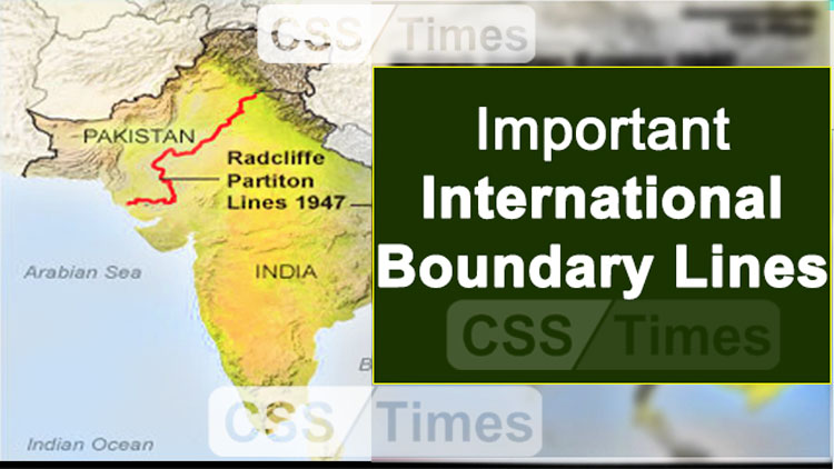
Radcliffe Line
Radcliffe Line was drawn by Sir Radcliffe. It marked the boundary between India and Pakistan. The Radcliffe Line was officially announced on August 17, 1947, a few days after the independence of India and Pakistan. The newly demarcated borders resulted into one of the biggest human migrations in modern history, with roughly 14 million people displaced. More than one million people were killed.
The Maginot Line
The Maginot Line named after the French Minister of War André Maginot, was a line of concrete fortifications, obstacles, and weapon installations built by France in the 1930s to deter invasion by Germany.
The Mannerheim Line
The Mannerheim Line was a defensive fortification line on the Karelian Isthmus built by Finland against the Soviet Union. The line was constructed in two phases: 1920–1924 and 1932–1939. By November 1939, when the Winter War began, the line was by no means complete
The Medicine Line
The medicine line, a hundred-mile stretch of the U.S. Canadian border at the top of Blaine County, Montana, epitomizes borderlessness . Natives called the border between Canada and the United States the Medicine Line, because during the 19th century Indian wars American troops respected it as if by magic. A century later, the medicine line deserves our respect for many different reasons: the history of peaceful coexistence it represents, and the model it offers for the future.
The Hindenburg Line
The Hindenburg Line is the boundary dividing Germany and Poland.
The Hindenburg Line was a German defensive position of World War I, built during the winter of 1916–1917 on the Western Front, from Arras to Laffaux, near Soissons on the Aisne.
The Mason–Dixon line
The Mason–Dixon line is a line of demarcation between four states in the United States.
Read also: 10 Surprising Facts About the Human Brain You Didn’t Know
The Oder–Neisse line
Oder–Neisse Line, Polish–German border devised by the Allied powers at the end of World War II; it transferred a large section of German territory to Poland and was a matter of contention between the Federal Republic of Germany (West Germany) and the Soviet bloc for 15 years. International Boundary Lines
The Siegfried Line
The West wall was a series of fortifications constructed between 1938 and 1940 along the western frontier of Germany between the Netherlands and Switzerland.
The Durand Line
The Durand Line is the 2,640-kilometer (1,640-mile) border between Afghanistan and Pakistan. It’s the result of an agreement between Sir Mortimer Durand, a secretary of the British Indian government, and Abdur Rahman Khan, the emir, or ruler, of Afghanistan. The agreement was signed on November 12, 1893, in Kabul, Afghanistan. International Boundary Lines
The McMahon Line
McMahon Line, frontier between Tibet and Assam in British India, negotiated between Tibet and Great Britain at the end of the Shimla Conference (October 1913–July 1914) and named for the chief British negotiator, Sir Henry McMahon. It runs from the eastern border of Bhutan along the crest of the Himalayas until it reaches the great bend in the Brahmaputra River where that river emerges from its Tibetan course into the Assam Valley. International Boundary Lines
17th Parallel
The dividing line between North Vietnam and South Vietnam as established by the 1954 Geneva Conference. The 17th parallel was buffered by a demilitarized zone, or DMZ, between the two countries. International Boundary Lines |
24th Parallel
The 24th Parallel line (Sir Creek) is the border located between India and Pakistan. Pakistan claims that it is the boundary between India and Pakistan in great Rann of Kutch (Gujarat). But this is not recognized by India.
26th Parallel South
The 26th parallel south latitude is a circle of latitude that is 26 degrees south of the Earth’s equatorial plane. It crosses the Atlantic Ocean, Africa, the Indian Ocean, Australasia, the Pacific Ocean and South
30th Parallel North
The 30th Parallel North is a circle of latitude that is 30 degrees north of Earth’s equatorial plane. It stands one-third of the way between the equator and North Pole and crosses Africa, Asia, the Pacific Ocean, North America and the Atlantic Ocean.
33rd Parallel North
The 33rd parallel north is a circle of latitude that is 33 degrees north of the Earth’s equatorial plane. It crosses Africa, Asia, the Pacific Ocean, North America and the Atlantic Ocean.
35th Parallel North
The 35th parallel north is a circle of latitude that is 35 degrees north of the Earth’s equatorial plane. It crosses Africa, the Mediterranean Sea, Asia, the Pacific Ocean, North America and the Atlantic Ocean.
The Parallel 36°30′ North
This parallel of latitude is particularly significant in the history of the United States as the line of the Missouri Compromise, which was used to divide the prospective slave and free states west of the Mississippi River, with the exception of Missouri, which is mostly north of this parallel.
International Boundary Lines | 37th Parallel North
The 37th parallel north is a circle of latitude that is 37 degrees north of the Earth’s equatorial plane. It crosses Europe, the Mediterranean Sea, Africa, Asia, the Pacific Ocean, North America, and the Atlantic Ocean
37th Parallel North formed the southern boundary of the historic and extralegal Territory of Jefferson.
International Boundary Lines | 38th Parallel
The 38th parallel in question is a circle of latitude 38 degrees north of the equatorial plane. This line divides the Korean peninsula roughly in half (leaving about 56% of Korean territory on the northern side). The actual border between North and South Korea slants across this circle of latitude, finishing some distance north of it on the east coast.
International Boundary Lines | 39th Parallel North
The 39th parallel north is a circle of latitude that is 39 degrees north of the Earth’s equatorial plane. It crosses Europe, the Mediterranean Sea, Asia, the Pacific Ocean, North America, and the Atlantic Ocean
International Boundary Lines | 40th Parallel North
The 40th parallel north is a circle of latitude that is 40 degrees north of the Earth’s equatorial plane. It crosses Europe, the Mediterranean Sea, Asia, the Pacific Ocean, North America, and the Atlantic Ocean.
International Boundary Lines | 41st Parallel North
The 41st parallel north is a circle of latitude that is 41 degrees north of the Earth’s equatorial plane.
It is the boundary between Nebraska and Wyoming and the southern boundary of Wyoming with Colorado and Utah.
International Boundary Lines | 42nd Parallel North
The 42nd parallel north a circle of latitude that is 42 degrees north of the Earth’s equatorial plane. At this latitude the sun is visible for 15 hours, 15 minutes during the summer solstice and 9 hours, 7 minutes during the winter solstice.
In the United States, the parallel passes through the states of Wyoming, Nebraska, Iowa, Illinois, Michigan, Pennsylvania, New York, Connecticut, Rhode Island and Massachusetts.
International Boundary Lines | 43rd Parallel North
The 43rd parallel north is a circle of latitude that is 43 degrees north of the Earth’s equatorial plane. It crosses Europe, the Mediterranean Sea, Asia, the Pacific Ocean, North America, and the Atlantic Ocean. It lies between the State of Nebraska and the State of South Dakota.
International Boundary Lines | The Parallel 440 North
The 44th parallel north is a circle of latitude that is 44 degrees north of the Earth’s equatorial plane. It crosses Europe, the Mediterranean Sea, Asia, the Pacific Ocean, North America, and the Atlantic Ocean.
International Boundary Lines | 45th Parallel
45th Parallel is the boundary between Wyoming and Montana. The 45th parallel north is a circle of latitude that is 45 degrees north of the Earth’s equatorial plane.
International Boundary Lines | 49th Parallel
49th Parallel is the boundary between USA and Canada. In the Anglo-American Convention of 1818, the United States and the United Kingdom negotiated the use of the land in the west for fishing, hunting and settlement. The two groups decided to make the 49th parallel the division between the two countries, for all land west of the Great Lakes, except for a small piece of Minnesota and the island of Victoria (Canadian). Canada would then be bound by this new line and Alaska (Russia) to the west. The U.S. was given the rights to fish off of Newfoundland and Labrador. Both countries would receive the right to hunt and fish in the Oregon Territory for ten years. Provisions were also made for any slaves that were on British soil or ships at the end of the War of 1812.
Follow our Facebook Page for daily updated materials >> CSS Times

Leave a Reply